Skipper Miles Moore of FunToSAIL.com will be racing in the 2027 WA360 that take place June 26th. A race around the Puget Sound from Port Townsend WA, past Seattle, to the Canadian border, through or by the San Juan Islands, across the Strait of Juan De Fuca and back to Port Townsend. Approximately a 360-mile round trip adventure that does not allow gas or electric motors, only sail and/or muscle power.
We are posting about this race well in advance in the hopes of securing sponsors/donors, to help with the race and to acquire funding for our accessibility work and suicide prevention.
With this race will be the start of the FunToSAIL.com video and article series about small boat adventure sailing, types of safety and general gear used, Float Plans, etc.
Miles is dedicating this race to suicide prevention. As one who has delt with depression all his life, this effort to expand awareness of resources to help prevent suicide is particularly important to him. Click here for resources.
It's also his goal to stream some parts of this event so those with disAbilities and others following the race can ask him questions live and some of the racing directly from his boat. Miles has a special part of his heart reserved for those with disAbilities due to his own challenges and seeing others struggle but prevail in life. He has been doing accessible and therapeutic sailing for 30+ years. In addition, has been developing an Inland NW marine access guide so those with disAbilities can find access to the water. Click here!
Miles has taught sailing for 40+ years via his sailing school here at FunToSAIL. He is a Recreational Therapist and previously worked for the state of Idaho as a Vocational Rehabilitation Counselor. Before going to college, he worked in the fishing industry in Westport WA.
Click the donation button above if you would like to support FunToSAIL's efforts.
It is with great excitement we announce that FunToSAIL.com is now the official producer of the Malbec18 sportboat. Learn more about the Malbec18 specifically by visiting its official page Click Here
We have made some changes to the boat to improve its user experience, such as…
1. New wireless navigation lights system.
2. New standard furling jib with no extrusion common with CDI furlers that make trailering and luff shape difficult. Has leach UV protection when furled.
3. New Mainsheet system.
4. New cabin seat hatches.
5. New Bimini option specifically designed for the Malabec18
6. And some improvements to the building process to improve build time and features.
7. No more blue or other colored hull boats. We have one blue hulled boat left to sell, going forward all boats will be white.
Centerboard work
Stay tuned on this site for updates about this boat and other topics.
Watch us race our Malbec18 in the upcoming distance race/regatta, the WA360, a race about the Puget Sound to the Canadian Border and back. Learn more by Clicking Here.
Here is one of my favorite YouTube sailing accounts, Ruddy Duck Sailing Adventures. I particularly love this channel because its local and he creates great videos/content. I am also planning on doing more videos this year and I take inspiration from him and his account.
Check out his videos at this link and reward is awesome work by subscribing...
I do not know about you but I like stories of adventure, etc. True stories about people being stranded on deserted islands fascinates me. This particular store was the inspiration for the book Robinson Crusoe. Here is one such story...
Hello fellow sailors, its time again for the Race 2 Alaska (R2AK) 2024, actually I am posting a bit late as some teams have already arrived in Ketichan Alaska, the big fast boats. I actually don't really follow the big boats but the small boats, boats 20' and under, kayaks, paddleboards, small day sailor dinghies, and Hobie cats.
This year I went to watch the start of the race, actually I arrived the day before to attend the pre race party and check out many of the boats and their gear (pics and more info coming soon). I was able to talk to many of the racers. They all seemed to be down to earth, regular people who have a desire for adventure and to test their abilities, yet none of them took lightly the challenge ahead.
I will be posting pics and boat and gear details via more post shortly.
The race started at 5:am on Sunday June 6. Many of the participants were up and getting their boats ready to go at 3:am, or earlier. I got up at 3:am and about half the racers were already at their boats.
The racers I was most interested in is Team Spirit of Nevetz skipper by Ohad Shafrir from Israel aboard his 16' catamaran (X Cat); Team Tips Up skippered by John Ped & Kaila Pfrang from Colorado USA aboard their 16' Hobie catamaran; Team X skippers by Xia Huang from USA/Singapore/China aboard his Hobie Mirage Tandem Island; Team Willy Wild Cat skippered by Adam Cove from Maine USA aboard his cat boat monohull; I was going to mention a few other teams but by this writing, sadly they have all ended their attempts, Did Not Finish.
The Worrell 1000 is back and is currently happening right now from May 12-25, along the east Coast of the United States. This was the race that all long distance high performance catamaran small boat sailors wanted to do, but it ended in the late1990's, but now its back in 2024.
Just a reminder that all lakes open to winter fishing in Inland NW (E WA., N ID, NW MT) will officially close this March 31 to fishing and boat launches (fishing and gates opens again the day after Black Friday on Sat.). Winter lakes for example in E WA. like Fourth of July Lake, Hog Lake, etc. It means again the lakes are closed to fishing and the gates to the access roads to the launches are locked.
However one can go over or through the gate or fence (cannot cause damage to the gate or fence of course) when fishing is closed and gates locked. The lands are public and access is allowed unless posted otherwise on the gate or fence. Always follow all rules as posted.
My wife and I like to access these lakes via hiking into them with our inflatable SUP's. Its nice for paddleboarding because there are no powerboats to deal with. Its quite and beautiful.
After a couple of challenging years, it's time to get our Inland NW Hobie Cat and Small Boat Sailor club going again. This is our first event of 2024 that will include a fun Saturday distance maze race through the sand islands of the Potholes Reservoir just below Moses Lake, WA. in Eastern WA. Prizes given! In the evening we will have a beach party.
Bring your kites. This area has amazing winds.
You can come for the day's events or stay longer and camp with us. We will camp for free on the northeast side of the reservoir.
Event takes place July 27, Saturday. Camping over the weekend.
Learn more about the Potholes Reservoir by Click Here!
Miles Moore of FunToSAIL will be applying to enter the Race 2 Alaska as Team FunToSAIL.com in 2025. This is a 750 m/1207 km race from Port Townsend WA USA to Victoria CAN (Vancouver Island), and onto Ketchikan Alaska. No gas or electric motors allowed, all muscle or sail power, or both.
Seven Devils Lake is located in Idaho County, Idaho, 19 miles up a very windy gravel road through the mountains with the start of this road from HWY 95 near and south of Riggins Idaho USA. The road called Seven Devils Rd/NF-517 takes you to the lake and campground that is next to Seven Devils Mountains, the tallest of which is called He Devil at 9,393', Windy Saddle Trailhead campground and lookout, Windy Saddle Horse Facility and campground, and to Heavens Gate lookout (8,429'). All 3 campgrounds are within a mile of each other and all have vault toilets, but no drinking water.
Wide lookout area before one gets to Windy Saddle, Seven Devils Lake, and Heavens Gate. Car in pic has its hood open to help cool it off as the temperatures were in the 90's even at this elevation. The road is very steep at times.
Seven Devils Lake is next to Seven Devils Mountains the names and highest of which from north to south are... Devils Tooth 7,830', Tower of Babel 9,268', He Devil 9,393', She Devil 9,280', The Ogre 9,210', Mt Belial 8,880' (definition of Belial is a biblical name of the devil or one of his friends), Devils Throne 8,280', Twin Imps 9,005' (Imps stand for small demon), and Pyramid Mtn 8,650'. It's home to a healthy population of Mountain and Mule Goats. Heavens Gate mountain and lookout at 8,429 in elevation that gives you a view of 4 states (Idaho of course, Oregon, Washington, and Montana) is just a few miles east of the Seven Devils mountain range. Once you are near the lake in a saddle area called Windy Saddle that includes a campground with vault toilet (and U shape parking area) the road splits, either taking you to the lake (west) or north (and slightly east) toward the Heavens Gate lookout gravel parking lot. At Heavens Gate parking lot there is a short half mile trail that is a steep hike (5-15% grade) to a ranger lookout tower that you can get on to get a 360 view of all 4 states. The trail to the top of Heavens Gate is single track and steep at times. One gets a beautiful view from Heavens Gate parking lot.
Few if any of the hiking trails (See hiking trails info in lower portion of this article) in the Seven Devils/Heavens Gate area is accessible to wheelchairs or any mobility devices (none of which were created or improved to be accessible). However it is possible to navigate with a wheelchair with/without assistances some of the trails around the Seven Devils Lake and Windy Saddle campgrounds. As you drive up the road before getting to the lake there are two nice wide fairly level lookout areas. First one is when you can first see the Seven Devils mountain range, which is a wide grassy area (nice place for wheeled mobility devices when the ground is dry) and the other is Windy Saddle that sits between the lake and Heavens Gate, also fairly level for wheeled mobility devices when dry. Off road tires are an absolutely must for any wheelchair/wheeled mobility device.
Common low riding road cars like a Toyota Corolla be driven all the way to the lake and lookout. However it can potentially be a rough drive and we so advise driving up with an SUV. Most of the year the road is muddy with lots of ruts, so an offroad vehicle during these times is advised. Most of the road vehicles going opposite ways can easily pass each other but as you near the top that is not the case. Best to drive up late June and no sooner. The road ascends from HWY 95 some 5,500 feet in elevation. Either way it is an amazing drive or ride via ones mountain bike (motorized vehicles or bicycles are only allowed on the designated Forest Service roads, not on trails, off the road). Going down can result in brake heat up so we advise taking your time and stop from time to time to see the views and let the brakes cool during those hot times of the year.
Trail to Seven Devils Lake
Seven Devils Lake is right at the base of mountains, which is part of the Seven Devils Mountains. The lake is surrounded by trees and is approximately 20 feet deep at its deepest. Its a fairly round lake of about 500 ft across. We did not find any official notes about fishing on this lake, even though some indicate there are trout in the lake. One can almost hike around the lake even though on the west side its steep and very rocky where some climbing is needed (not rock climbing). The lake is on the south side of the campground. The trail to the lake exits (south) off the circular gravel/dirt road that goes through the campground. The trail starts with a steep short incline of 15%, then levels out through a small field (may be filled with water or muddy during wet times of the year), then climbs slightly when close to the lake, walking over rocks and some roots. Once you can see the lake then the trail disperses wide and descends down a steep 20% bank to the waters edge. If using a wheelchair you could get close enough with assistances to see the lake. Perfect lake to just chill next to and take in the sights, such as the super high cliff at the lake.
Seven Devils Campground access road
There is a primitive camp ground right by the lake with primitive 10 campsites. Most campsites you can park next to your tent or small camp trailer (would be hard to bring a large RV or camp trailer into this campground). Its a first come, first serve campground. No reservations are available. The lake sits in a bowl like protected area next to the mountains. So if a wind storm comes this campground is fairly protected. The Lake is on the south side of the campground, 0.2 miles away. There is one accessible vault toilet in the campground area. No fees currently are charged to use this campground.
This is the trail exiting from Windy Saddle Trailhead Campground. One can hike this trail a few miles and turn back or do the loop that is approximately 17 miles long.
There is another campground nearby on Windy Saddle Trailhead campground with no official total number of campsites designated. This campground has few trees and is very exposed to wind. The lack of trees in this area was due to a wildfire a few years ago. There is one accessible vault toilet in this campground and parking viewing area. Because the whole campground is in an open area and fairly level its a good location for wheelchair access/mobility devices. One has to park in the gravel/dirt/mud parking lot and then walk a short distance to ones campsite, so this campground is only for tents. No fees currently are charged to use this campground.
There is east of Windy Saddle what is called Windy Saddle Horse Facility and Campground, where vehicles pulling horse trailers can park on the same mountain as the Heavens Gate lookout. This site is an open area with some leveled out parking gravel spaces. There are 4 designated campsites with room enough for vehicle and horse trailer. This area has few trees and is very exposed to wind. The lack of trees in this area was due to a wildfire a few years ago. There is one accessible vault Toilet. Because the whole parking area is on a slope, its not an ideal place for wheelchairs/mobility devices. The road going through the horse parking area is sloped at 5-15% grade.
This lake, the area mountains, campgrounds, etc. are all not very well known, but still well visited mostly by locals. Was strange as it was hard to acquire information about this area, thus its low visits, and thus one of the reasons we wrote this article, the other reason is to supply disability related accessibility information. Visiting this area mid week or late summer (after school starts) is best if one wants to avoid tourists. Learn more at the Forest Service website who maintain these sites https://www.fs.usda.gov/recarea/wallowa-whitman/recarea/?recid=51645
Fishing/Wildlife: Fish unknown, Geese, Ducks, Mountain Goats, Mountain Lions, Black Bears, Deer, Elk.Directions:One-half mile south of Riggins on Hwy 95 turn west onto Seven Devils Rd/NF-517(there is a tall billboard on the opposite side of the start of Seven Devils Rd on HWY 95). There is a good size Forest Service sign that says "Hells Canyon National Recreation area and Seven Devils" that is posted on HWY 95. For some reason this sign is only visible traveling south on HWY 95, not going north.This road is 19-miles long that has several lookouts, Seven Devils Lake, Seven Devils Mountains, 2 campground, Heavens Gate Lookout, and the Hells Canyon Wilderness area. The gravel road can be rough at times with ruts. During spring or fall, or wet times of the year the road can be very muddy and treacherous. Best to travel this road no early than late June for offroad vehicles and late July for passenger cars. Using an SUV or offroad vehicles is advised.
SEVENS DEVILS LAKE AND CAMPGROUND ACCESSIBILITY: PARKING... Level to mostly unlevel gravel/rocky/dirt/mud small parking areas in and around campground; PATHS/TRAILS... No paved paths. There are primitive single track rocky dirt trails and open grassy/rocky/dirt/mud areas throughout the campground and at/by the lake. All trails have deep descents once near the lake. Also the non wheeled mobility accessible trail 123 exist the west side of the campground to Sheep Lake and He Devil Mountain, etc.; RESTROOMS/FACILITIES… One fully accessible vault toilet; SENSORY... No sensory tactile markers for those with visual and other impairments. DOCKS/LAUNCHES/PLATFORMS… No docks or platforms; DIRECT WATER ACCESS… No access for wheeled mobility devices; TRANSFER SYSTEMS... None; CAMPING... 10 primitive non designated accessible campsites. There are several fairly level campsites that wheelchairs with offroad tires could navigate. No picnic tables; O.T.H.E.R… Oddities/Barriers: Very rocky, dirt, and mud (wet times of year), wood debris; Terrain: Level to very steep; Environmental Conditions: Cold and windy in the winter and hot during the later summer months. This campsite has lots of big trees the supply shade in the hot summers, plus the mountains create a shadow as the sun moves west. Due to its high elevation its tends to be cool most times of the year; Resources: No drinking water available at the campground or nearby. Food, drinks, and gas at town of Riggins off of I95. Forest Service Link.
WINDY SADDLE TRAILHEAD CAMPGROUND AND LOOKOUT PARKING AREA ACCESSIBILITY: PARKING... Mostly level gravel/dirt/mud parking near campsites; PATHS/TRAILS... No paved paths. No designated trails to campsites. There are primitive single track and open space through rocky dirt trails that descend away from campground. All trails away from campground have deep descents due to the campground being in a saddle high on a mountain. Dirt road to Seven Devils Lake and Heavens Gate lookout includes potholes and ruts, road to Heavens Gate includes a 5-7% grade. There are two trails from this area, Seven Devils Trail #124 and Sheep Creek Trail #53 which enter Hells Canyon Wilderness; RESTROOMS/FACILITIES… One fully accessible vault toilet; SENSORY... No sensory tactile markers for those with visual and other impairments; CAMPING... Approximately 10 primitive non designated non accessible campsites. Most campsites are fairly level that wheelchairs with offroad tires could navigate. Once one leaves a campsite all terrain is sloped at 10-18%, and more. No picnic tables; O.T.H.E.R… Oddities/Barriers: Very rocky, dirt, and mud (wet times of year), wood debris; Terrain: Level to very steep; Environmental Conditions: Cold and windy in the winter and hot during the later summer months. This campsite has no significant trees to supply shape, so this campground is very open to bad weather such as wind, rain, etc. Due to its high elevation its tends to be cool most times of the year; Resources:No drinking water available at the campground or nearby.Food, drinks, and gas at town of Riggins off of I95. Forest Service Link.
WINDY SADDLE HORSE FACILITY BETWEEN SEVEN DEVILS LAKE AND HEAVENS GATE LOOKOUT ACCESSIBILITY: PARKING... Level to mostly unlevel gravel/dirt/mud parking for vehicles with horse trailers ; PATHS/TRAILS... No paved paths. There are primitive single track rocky dirt trails throughout the facility. All trails have somewhat steep descents due to the campground being on the side of a mountain of 5-15%; RESTROOMS/FACILITIES… One fully accessible vault toilet; SENSORY... No sensory tactile markers for those with visual and other impairments. CAMPING... 4 campsites on fairly level gravel/dirt/grassy ground with picnic tables; O.T.H.E.R… Oddities/Barriers: Gravel, dirty, and mud (wet times of year); Terrain: Overall from moderate slope of 5% to steep at 15%; Environmental Conditions: Cold and windy in the winter and hot during the later summer months. Due to its high elevation its tends to be cool most times of the year; Resources:No drinking water available at the facility or nearby.Food, drinks, and gas at town of Riggins off of I90. Forest Service Link.
HEAVENS GATE PARKING LOT AND TRAIL HEAD ACCESSIBILITY: PARKING... Level gravel and dirt parking area at trailhead. Parking lot will accommodate about 20 vehicles. Road leading to parking lot from Windy Saddle is 5-7% grade; PATHS/TRAILS... No paved paths. There is one half mile primitive single track rocky dirt trail to and from the lookout that is absolutely not accessible to wheelchairs/wheeled mobility devices with 10 to 20% grade. Once at the top of the mountain there is a lookout ranger building that the public is allowed to access. There are about 20 steps to a railed walkway around the building. Inside of the building is open in the summer typically when the seasonal volunteers are there, otherwise the buildings door is locked. There is a guest book to sign; RESTROOMS/FACILITIES… One fully accessible fault toilet at parking lot; SENSORY... No sensory tactile markers for those with visual and other impairments. CAMPING... No. Camping nearby at Windy Saddle Trailhead Campground, Windy Saddle Horse Facility Campground, or Seven Devils Lake Campground; O.T.H.E.R… Oddities/Barriers: Very rocky, sand, and mud; Terrain: Level at parking lot, other than that the trail is very steep, 10-20% grade. Lots of sand, rocks, mud (wert times of year); Environmental Conditions: Cold and windy in the winter and hot during the later summer months. Due to its high elevation its tends to be cool most times of the year; Resources:No drinking water available at the lookout area or nearby.Food, drinks, and gas at town of Riggins off of I90. Forest Service Link.
He Devil Mountain and Sheep Lake
HIKING TRAIL 123, HE DEVIL/SHEEP LAKE. He Devil Mountain (45.324135°N 116.548418°W)... This hiking section is a work in progress as we will visit this area again in late summer of 2024. This is a full day hike. We have not found this trail noted on any maps offered, other than on the map below that was drawn by a hiker and noted by other hikers. We added the trail to our basic trail map, that shows all the main trails. The trail is noted by the Forest Service, yet not on any of their maps. Also no official length of the trail, we are estimating 6-7.5 miles. We will have an official length once we hike this trail this late summer 2024. The trail is not wheelchair accessible. Progressing toward the mountain the trail is single track to no trail up steep climbs (no rock climbing) and bouldering. This hike requires one to be in shape with excellent leg/ankle strength and balance at times with no hiking stick. Some bouldering requiring to use ones hands/arms. One must use hiking boots, full day+ of water and food, with appropriate clothing for environmental exposure of sun, heat, cold, rain, snow, etc. Make sure you have a first aid kit. Climbing this mountain early summer/June and late October when icy, snow covered, is not recommended.
Some who do this hike will primitive camp along the shore of Sheep Lake to allow more time to hike this and other mountains like She Devil. And have time to fish, etc.
There are several hikes around the Seven Devils Mountains but in this text we are going to focus on the He Devil Mountain/Sheep Lake hike via a trail 123 from the west side of Seven Devils Lake Campground, not from Windy Saddle which increases the length of the hike significantly. One must get off the trail once near the mountain to hike a ridge to the mountain top (9,393 ft).
He Devil from the northeast showing major features, the approximate location of the Sheep Lake Trail(123)and a recommended departure area. It is also possible for some who have excellent strength and steep hiking abilities to leave the trail and climb more straight up.
Closeup of the lower NW Ridge to top of He Devil. The easiest access is up the shallow couloir to the deep notch/saddle on the right. Once on the ridge one will notice a short piece of a trial. Trail does not last due to hiking over rock.
The last bit of He Devil involves a scramble/bouldering to get to where the cairn is with a register in a white tube located at the base of the cairn. Once up at the top there are two elevate spots to view the surrounding area. Takes some scrambling/bouldering to get to and from the points.
On the NW Ridge of He Devil. Lakes below are (L to R) Triangle, Quad, He Devil (with island) and Echo. Devils Canyon in the background.
Some of the hiking info by Bob Bolton and photos via Fred Spicker, August 2008
Amazing Atlantic Ocean racing in the Transat. Great video. Just turn off the sound (keep the sound on the first time you watch so you know what's going on) and put it on your big screen TV and let it play over and over. Relaxing's to watch.
Columbus Day is October 12th and also on this day I call it Discovery Day as there were the Vikings and others who also landed in North American (Columbus actually landed in Cuba and the Bahamas). Some indigenous people who are my ancestors crossed the land bridge into North America but who knows maybe some actually traveled on boats as some archologists are suggesting this. There are also some stories of religious groups landing in North, Central, and South America. So, there are a lot of possible landings that took place in discovering of North America, and all of the Americas.
My thought is to celebrate the brave skippers, crew, and passengers that were willing to go out on the unknown seas to discover lands that they had no idea where there but with great faith and spirit of adventure were willing to do what others of their day would not do.
Christopher Columbus should be celebrated for his bravery to cross the unknown seas (4 times) with his entrepreneur spirit to open a shipping route for spices, etc. to and from Asia, but ended up instead creating paths to the Americas. Some did think the world was flat so then there was that attitude he had to deal with. He did not believe the world was flat. He also felt he was bringing the good news of the Gospel of Christ to the world via his voyages. He also had to convince royalty to finance his trip and keep the sailors aboard his ships from killing him. He was a brave man that took many risks to open the oceans to trade and exploration. See the video below...
Columbus in particular was the sailor who started the process that one day would end up creating the freest and prospers nation on earth, the United States of America.
So let us celebrate the spirit of Columbus and all brave sailors who did what seemed impossible.
At FunToSAIL we will start producing Adventure Sailors Series to discuss various ancient voyages that likely happened all over the world and related topics. Stay tuned!
Sprague Lake is the largest lake in at 1,841 acres. This lake is in Adams & Lincoln Counties with 1 public launch and one resort launch in Adams County and 1 resort launch in Lincoln County. Some people think this lake is in Spokane County, which it is not. This large lake is two miles west of the town of Sprague, along the south side of I-90. It was called Big Lake in some old surveys and until 1950 was known as Colville Lake, Changed to Sprague Lake in the 1970's. This is a windy lake with winds typically coming from the west and at times can exceed 20 knots. This is a fantastic sailing lake due to the consistent winds and open water, and great for Ice sailing as well. Due to the consistent winds on this lake it's not so good of course for water skiing, not to forget that his lakes shoreline and some places there are rocks, lots of rocks. This a fishing or sailing onlylake! Not good lake for anything else due to algae develops in July when it gets hot and there are leaches in the lake as well, so not good for swimming, waterskiing, or tubing. Harper Island which is a bird sanctuary is on the S.W. end of the lake. This is a very popular fishing lake for walleye, largemouth and smallmouth bass, crappie, channel catfish, perch, bluegill, and rainbow trout. Access is southwest through the town of Sprague. Washington Department of Fish and Wildlife has one public boat launch on the southwest end of the lake, and there are two a private boat launches in association with two resorts with day use fees on the southeast and northeast end of the lake. Fishing: Black Crappie, Bluegill, Catfish, Largemouth Bass, Rainbow Trout, Spiny Ray, Walleye, Yellow Perch. Lake Dimensions & Coordinates: 1,841 acres; Maximum depth estimated at 65 ft; elevation 1878 ft; Coordinates T20/21N R37/38E. Longitude 118d 1m 4s -to- 118d .6m 10s west. Latitude 47d 14m 15s -to- 47d 17m 28s N. Info:City of Sprague info at this link http://www.sprague-wa.us .
-- Pic Coming Soon -- 1. WDFW Southwest Public Boat Launch This launch site has a single lane paved boat launch with a single dock (dock is not normally in place due the lake seemingly always to shallow to have it in place), toilet, lots of room for parking. The water depth at this site is shallow of only 2-3 ft at low water times of the year, which is most of the year. Large gravel parking lot and public accessible restroom. There is a tree that overhangs the launch site so those launching sailboats will need to step mast in the water if the mast is too tall.
ACCESSIBILITY: PARKING... Gravel parking area for vehicles and boats. Paved accessible parking next to restroom and boat launch; PATHS/TRAILS... One paved path to and from restroom from upper parking area. No paved path to launch; RESTROOMS/FACILITIES… One accessible restroom with accessible parking next to it; SENSORY... No sensory tactile markers for those with visual and other impairments. DOCKS/LAUNCHES/PLATFORMS… One dock that may or may not be in place due to the lakes typical shallow water level. More than not the dock is not in place creating a significant barrier to persons using mobility devices to access the water. One paved launch of 3 to 5% grade into shallow water with two accessible parking spaces next to it. The launch pavement transitions from blacktop to long vertical concrete slats; DIRECT WATER ACCESS… No access for wheeled mobility devices to directly access the water; TRANSFER SYSTEMS... None; CAMPING... None. There are two camping/RV resorts on this lake; O.T.H.E.R… Oddities/Barriers: There is a tree overhanging the launch that can interfere with masts of sailboats and super rocky shoreline, with some submerged rocks just under the surface of the water; Terrain: Level to 3 to 7 % grades. Shoreline is very rocky and sandy/muddy. Pavement next to restroom and at launch area; H2O/Water: Water on this lake is never really clear and in late summer is murky with algae. Not ideal for swimming. Water temperature in the summer can be around 70-90 degrees; Environmental Conditions: Little to no currents. Water can become stagnant. High winds are common in this area; Resources: Food, drinks, and gas within town of Sprague.
2. Four Seasons Resort Four Seasons Resort is located on the west end of the lake on the north shore. This is a well-developed and old resort with tent and RV campsites, nice restroom, store, several docks, and a single gravel/muddy boat launch suited for light weight boats. The resort also rents fishing boats. This is not a state park supported by a large budget from our hard-earned tax dollars. Its rustic and old, so do not expect some Richy fancy resort. These nice old resorts need your support. 509-257-2332. I feel 4 Seasons is best used for sailing due to the depth you can launch into and quick access to the windier part of the lake. Directions: From Spokane on I-90 W. take 245 and from there you follow the signs to the resorts, etc. The town of Sprague is really run down for example you will turn on B street to get to 1st. street yet 1st street is marked incorrectly as B Street. So going to the resorts and landings you follow B street to B Street.
ACCESSIBILITY: PARKING... Gravel parking; PATHS/TRAILS... None; RESTROOMS… Well maintained and fully accessible to wheelchairs; SENSORY... No sensory tactile markers for those with visual and other impairments. DOCKS/LAUNCHES/PLATFORMS… Two docks, one of which one could access with a wheelchair (not ADA compliant); DIRECT WATER ACCESS… No access for wheeled mobility devices; TRANSFER SYSTEMS... None; CAMPING... Tent and RV camping with full hookups; O.T.H.E.R… Oddities/Barriers: Nothing unusual; Terrain: Level to 3% grade. Large grassy areas and gravel roads and walkways; H2O/Water: Water on this lake is never really clear and in late summer is murky with algae. Water temperature in the summer can be around 70 degrees; Environmental Conditions: Little to no currents. Water can become stagnant. High wind and hit are common in this area; Resources: Food, drinks, and gas within town of Sprague.
3. Sprague Lake Resort This resort with launch is located on the northeast end of the lake http://www.spraguelakeresort.com / 509-257-2864). Has cabins, tent, and RV sites, restrooms, and docks. Has very primitive with mud/dirt/gravel launch. This is not a state park supported by a large budget from our hard-earned tax dollars. Its rustic and old, so do not expect some Richy fancy resort. These nice old resorts need your support.Directions: From Spokane on I-90 W. take 245 and from there you follow the signs to the resorts, etc. The town of Sprague is really run down for example you will turn on B street to get to 1st. street yet 1st street is marked incorrectly as B Street. So going to the resorts and landings you follow B street to B Street.
ACCESSIBILITY: PARKING... Gravel parking; PATHS/TRAILS... None; RESTROOMS/FACILITIES… One well maintained restroom but not accessible to wheelchairs; SENSORY... No sensory tactile markers for those with visual and other impairments. DOCKS/LAUNCHES/PLATFORMS… Two docks, not wheelchair accessible. One gravel rock launch of about 3% grade into shallow water; DIRECT WATER ACCESS… No access for wheeled mobility devices; TRANSFER SYSTEMS... None; CAMPING... Tent and full hookup RV campsites; O.T.H.E.R… Oddities/Barriers: Nothing unusual; Terrain: Level to 3% grade. Very rocky and sandy; H2O/Water: Water on this lake is never really clear and in late summer is murky with algae. Water temperature in the summer can be around 70 degrees; Environmental Conditions: Little to no currents. Water can become stagnant. High wind and hit are common in this area; Resources: Food, drinks, and gas within town of Sprague.
Click on map to enlarge or to print
Click on map to enlarge
Both pictures of 4 Seasons Resort on the northwest end of the lake, next to HWY 90.
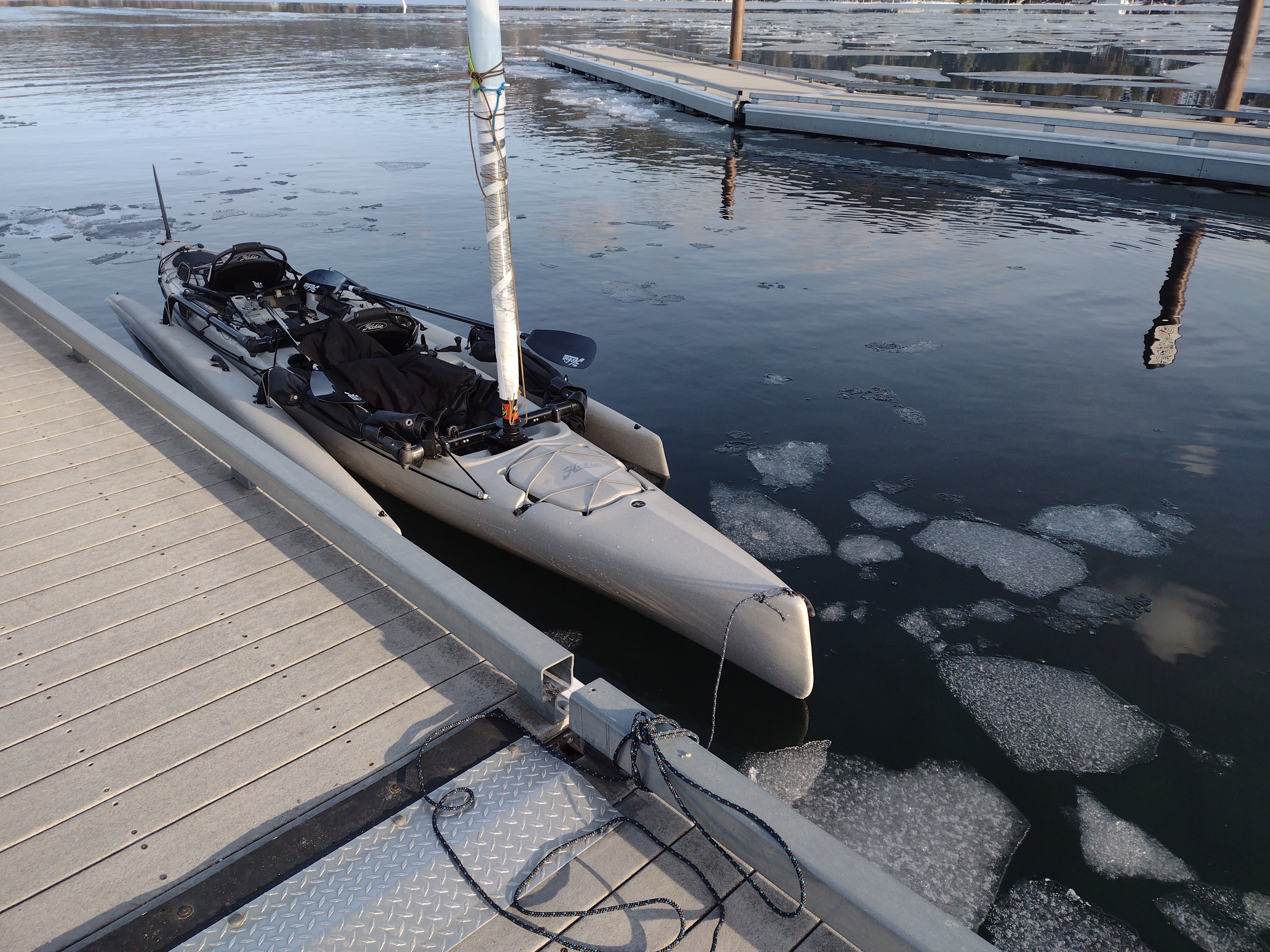
When you think of Ice Sailing one might think of those fast sail sleds on ice blades, however my wife and I sailed my Hobie Mirage Tandem Island (TI) not on the ice but in the water among the broken ice. I love the time of year when the ice breaks up enough to create channels and areas to boat in with the ice still present. I wanted to have fun among the ice before it melted. Interesting to note when we launched our TI we had to push the boat through the ice, but after a couple hours of sailing when we got back near and at the launch there was not much ice left (lots of ice still out in the lake). My wife jokes that I am such a kid about playing out on the water, flying kites, etc. Boating among the ice really brings me a lot of joy.
On a safety note, always make sure you have your PFD/Life Jacket on, dress in layers, and use a boat that is stable (will not capsize). Make sure to have your boats required safety gear on board. The most dangerous time to boat is when the water is cold.
Here are some videos and pic of our ice adventure...