Herman Lake is a private lake with no public access. If you are in the area you may hear about the lake, so it is appropriate to mention here. Herman Lake is near the junction of Herman Lake Cutoff Road & Old Hwy two, known locally as "Herman Junction." Where these two roads meet Hwy 2 turns to gravel, so if you want to stay on pavement use Herman Lake Rd. Directions: To view Herman Lake and so some bird watching from the road take HWY 2 from Bonner Ferry's and then turn north onto Herman Lake Rd. Herman Lake Rd off of HWY 2 is just 3 miles from the Idaho Montana boarder. Maps: View Google Map below...
As of this announcement date, peak runoff has not occurred, though it is approaching. The lake will peak soon after. The goal will be to have the lake to at least 3.0 feet by Friday, May 23rd. Weather and precipitation will influence the level the lake peaks at as well as the time it reaches peak. Once peak lake level has occurred, the lake level will be stabilized through gate operations.
As you’re likely aware, the type-of-year designation determines whether the lake level will be stabilized at 3.0 feet (for wet years) or between 3.0 to 3.5 feet (for dry years), in accordance with Idaho Code 70-507. We’ve reviewed information from several agencies to make the type-of-year determination.
The National Resources Conservation Service (NRCS) forecast issued in early May shows below average values of streamflow volume are expected for the Priest River basin.
In accordance, the National Oceanic and Atmospheric Administration (NOAA) released a Seasonal Outlook for temperature and precipitation that predicts hotter and drier-than-normal conditions for North Idaho in the May through July timeframe.
The US Drought Monitor reports current conditions are abnormally dry for the Idaho panhandle.
Furthermore, the National Aeronautics and Space Administration (NASA) reports soil moistures of 10% or less in the Idaho Panhandle, suggesting drought conditions.
These predictions all point to a “dry” type of year, and therefore, operations are planned to hold the lake level between 3.0 and 3.5 feet during the recreation season. Specifically, IDWR plans to hold the lake at 3.38 feet early in the recreation season. Once flow in the Priest River drops to 200 cfs (likely in July or August), the lake level will be allowed to drop gradually from its current level to 3.0 feet through September 30th to augment the river flow.
Additional updates will be released in the May-June time frame, and any revisions to the plan will be announced then.
For questions contact Michelle Richman, IDWR Northern Regional Manager, northerninfo@idwr.idaho.gov or (208) 762-2800.
Mountain Meadows Lake This lake is located about 12 miles from Newport, in Pend Oreille County, WA. Fishing on this lake is done from the bank off of the county owned Deeter Road (see white arrow in map below). We want to make it clear this lake is totally privately owned shoreline other that the one spot indicated in the map below. DO NOT access private land and obey all county/state and private landowner signs. Deeter Road which is a dead-end road that is on the east side of the lake, along the shore is county owned and allows public access unless otherwise posted by the county. This road connects to Baker Rd, which is a private road and does not allow access and is typically gated (if gate is open, do not enter). Making the effort to accessing this lake makes no sense when there are so many beautiful public lakes in the area.
This lake's shoreline is heavily lined with lily pads and other aquatic plant life making fishing from the bank from the one spot along the county road difficult. Waterfowl make this lake their home. No hunting allowed. There are some reports that this lake is 20-30 deep, but there is no verification of this, all info we have found at its deepest in early spring is about 10 ft deep. Due to its shallow depth with warm water in the summer Alge build up is a given, plus its marsh conditions makes this lake home to a lot of mosquitos. Fishing: Limited info, Crappie and Bass. Not stocked by state fisheries. Directions/Maps: Visit google.com/maps type in Mountain Meadows Lake or GPS coordinates 48.196151, -117.225960
Attention... Obey ALL private and county/state signs!
ACCESSIBILITY: PARKING... Gravel, Dirt combo parking along road (park totally off paved road); PATHS/TRAILS... None; RESTROOMS/FACILITIES/SHADE… None. Some shade via trees; SENSORY... No sensory tactile markers for those with visual and other impairments. DOCKS/LAUNCHES/PLATFORMS… None. Launch off very small bank through grass and then lily pads (see white arrow on map below); DIRECT WATER ACCESS… No access for wheeled mobility devices; TRANSFER SYSTEMS... None; CAMPING... No; O.T.H.E.R… Oddities/Barriers: Deep grass, Lily pads; Terrain: Level to about 4% along lake; H2O/Water: Water normally murky. Water temperature in the summer can be around 60 to 70 degree. No drinking water available; Environmental Conditions: Varies; Resources: Food, drinks, and gas in in towns of Newport and Diamond Lake, WA.
Green line indicates private land. Yellow line is public county owned road. White arrow indicates only location where can fish at. One must obey all private, county, and state signs.
Red arrow indicates only location where one can fish at. One must obey all private, county, and state signs.
Skipper Miles Moore of FunToSAIL.com will be racing in the 2027 WA360 that take place June 26th. A race around the Puget Sound from Port Townsend WA, past Seattle, to the Canadian border, through or by the San Juan Islands, across the Strait of Juan De Fuca and back to Port Townsend. Approximately a 360-mile round trip adventure that does not allow gas or electric motors, only sail and/or muscle power.
We are posting about this race well in advance in the hopes of securing sponsors/donors, to help with the race and to acquire funding for our accessibility work and suicide prevention.
With this race will be the start of the FunToSAIL.com video and article series about small boat adventure sailing, types of safety and general gear used, Float Plans, etc.
Miles is dedicating this race to suicide prevention. As one who has delt with depression all his life, this effort to expand awareness of resources to help prevent suicide is particularly important to him. Click here for resources.
It's also his goal to stream some parts of this event so those with disAbilities and others following the race can ask him questions live and some of the racing directly from his boat. Miles has a special part of his heart reserved for those with disAbilities due to his own challenges and seeing others struggle but prevail in life. He has been doing accessible and therapeutic sailing for 30+ years. In addition, has been developing an Inland NW marine access guide so those with disAbilities can find access to the water. Click here!
Miles has taught sailing for 40+ years via his sailing school here at FunToSAIL. He is a Recreational Therapist and previously worked for the state of Idaho as a Vocational Rehabilitation Counselor. Before going to college, he worked in the fishing industry in Westport WA.
Click the donation button above if you would like to support FunToSAIL's efforts.
Bells Lake is between the St. Joe River and road NF-50, about 5 miles north of St. Maries, Idaho. Not really a good lake to go boating as there is no real way to get a boat into the lake. However the Idaho Fish & Game indicates fishing on this little lake that looks more like a pond. For fishing info visit this link... Fishing Bell Lake. Also a good place to bird watch.
ACCESSIBILITY: Difficult access... view lake from road. Could access lake over steep bank and then portage through marine vegetation. Certainly not accessible to wheeled mobility device.
It is with great excitement we announce that FunToSAIL.com is now the official producer of the Malbec18 sportboat. Learn more about the Malbec18 specifically by visiting its official page Click Here
We have made some changes to the boat to improve its user experience, such as…
1. New wireless navigation lights system.
2. New standard furling jib with no extrusion common with CDI furlers that make trailering and luff shape difficult. Has leach UV protection when furled.
3. New Mainsheet system.
4. New cabin seat hatches.
5. New Bimini option specifically designed for the Malabec18
6. And some improvements to the building process to improve build time and features.
7. No more blue or other colored hull boats. We have one blue hulled boat left to sell, going forward all boats will be white.
Centerboard work
Stay tuned on this site for updates about this boat and other topics.
Watch us race our Malbec18 in the upcoming distance race/regatta, the WA360, a race about the Puget Sound to the Canadian Border and back. Learn more by Clicking Here.
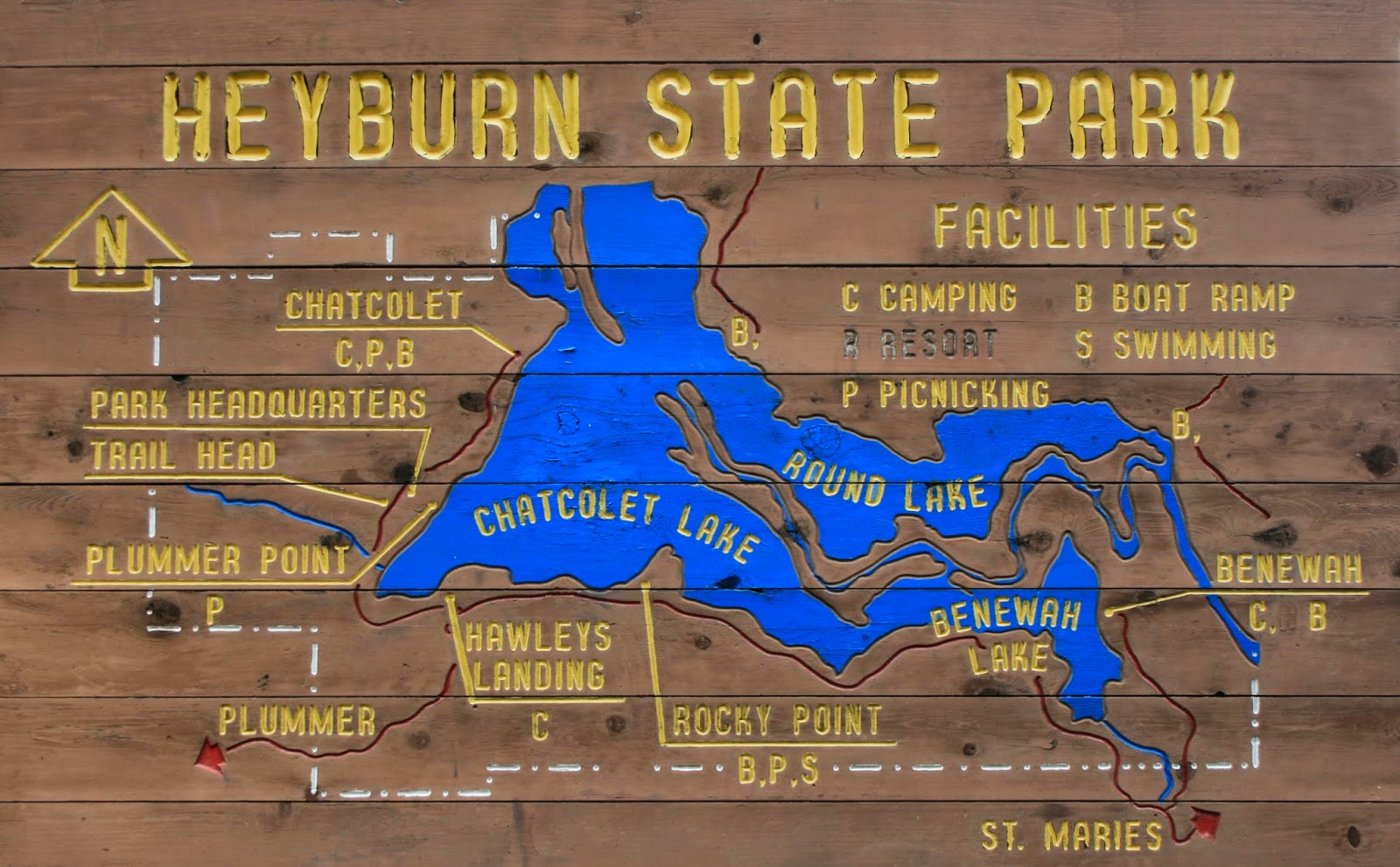
Heyburn State Park / 4 lakes area is one of the camping, boating, and fishing jewels of the state of Idaho. Heyburn S.P. consists of several large camping areas, cabins, numerous hiking trails, 3 boat launch facilities, beaches, and wilderness area. The bike trail called the Trail of the Coeur d'Alene is connected to this park. There are four lakes that were created/expanded by the Post Falls dam in this park area (and more beyond the park). These 4 lakes are on the southeast end of Lake Coeur d'Alene, some might thing these 4 lakes is just a continuation of Lake Coeur d'Alene as all the water is very much connected to each other and the St. Joe River. The largest of these 4 lakes (excluding Lake Coeur d'Alene) is Chatcolet Lake (off of St. Joe River, south). To the north of Chatcolet lake is Hidden Lake; to the east is Round Lake, and also to the east and south of Round Lake is Benewah Lake. The St. Joe River (see info below and in the St. Joe River section of this site) runs through these lakes in a unique channel system that boaters can use to access the city of St. Maries and beyond. Connected to the St. Joe River in the City of St. Maries, is the St. Maries River.
Lake Chatcolet is the largest of the four lakes. It consists of 600 acres and has more open water and boat launches than the other three lakes. Round Lake, the second largest lake, consists of 410 acres and is known for it's great fishing. However, due to all the aquatic vegetation and it's shallow depth, it isn't suited to high-speed boating. You can sail in this lake but by mid-summer there will be too much aquatic plant life fouling your rudders, etc. Benewah Lake is the 3rd largest; it consists of 400 acres and is another shallow lake with lots of aquatic plant life. This is another excellent fishing lake. The last and smallest of the 4 lakes is Hidden Lake, which consists of 90 acres, and is more like a bay connected to Lake Chatcolet and St. Joe River, than like a lake. Beyond the park and up river on the St. Joe River there is one large shallow lake (See Hepton Lake) and 3 smaller lakes next to the St. Joe River.
Lake Chatcolet is the only lake of the 4 I think are worth sailing on due to its lower level of weeds and deeper water. The other 3 lakes are perfect for fishing and kayaking/canoeing. And again, the St. Joe River would be great to either motor or kayak/paddle up. I have actually sailed and motored my sailboat up this river, a fun trip for sure. Regardless of what style of boat you use, experiencing where the river runs through is a credible experience.
Visit specific lakes via index for accessibility levels... Click Here!
Here is one of my favorite YouTube sailing accounts, Ruddy Duck Sailing Adventures. I particularly love this channel because its local and he creates great videos/content. I am also planning on doing more videos this year and I take inspiration from him and his account.
Check out his videos at this link and reward is awesome work by subscribing...
Below is a forwarded message from the USACE that Flexible Winter Pool Operations (FWPO) have been requested by BPA this year and the USACE will accommodate that request by adjusting the operations at Albeni Falls Dam temporarily. The notice shows they will likely raise Lake Pend Oreille (LPO) by 3 feet over the next couple days. They will likely release that water in the near future to generate power. As a reminder, FWPO is an agreement with Bonneville Power Administration (BPA) that allows them to request LPO be filled up to 5 feet in the winter and then released again to generate power when power is in demand. FWPO, and power generation overall, is the reason we have had a maximum lake drawdown for the past 10 years. 2013 was the last year LPO was held at a high winter pool of 2055.5'.
Lakes Commission Meeting Adjustment: January 9th is postponed. Since our agenda has numerous USACE speakers, we are attempting to reschedule our meeting. Stay tuned! We will let you know ASAP of the new date. Zoom link for attending virtually, will remain the same.
Hayden Lake (3,880 acres), with its crystal clear waters, sandy beaches and picturesque timber shores... is one of the most beautiful and popular lakes of Northern Idaho. It's irregular shape gives it about 40 miles of shoreline with the main portion of the lake being seven miles long and one to two miles wide. Normal lake elevation is 2,239 ft. above sea level, and portions of it reach 178 ft. deep. The lake is surrounded on three sides by panoramic timbered mountains which rise to an elevation of 4,500 to 6,000 ft. In the early years as many as four steamboats served the lake industry, and Bing Crosby built a summer home on its shores.
Hayden lake is a great sailing lake and I have personally sailed many times on this lake. Its winds are similar to Lake Coeur d’Alene’s with Spring and Fall having the best winds; winter also has nice winds but they are lighter than Spring and Fall winds. Summer winds are light during the day with morning and late evenings producing nice thermal winds (from the East or West). This lake tends to produce winds from all different directions during mid day and seems to not have consistent wind patterns other than in the morning and evenings, but it is still a very enjoyable lake to sail on. This lake is a popular location for water skiing and fishing.
There are two boat launches on Hayden lake, one on the Southwest end (Honeysuckle) and one on the Northeast end (Sportsmen Access). There is also a private marina just a short distance from the Honeysuckle Launch to the Southeast from this boat launch. Honeysuckle Beach boat launch and park is located on the east end of Honeysuckle Avenue and is by far the best public launch facility and the only one you could launch a swing keel sailboat from. Hayden Lake Sportsmen Access is on the Northeast end of the lake. Hayden Lake is suited for dinghies and has a steep road down to the ramp (I really do not feel this is a good place to launch a sailboat of any kind from. It's best suited for kayaks & dinghies 16’ and under).
Directions: From Hayden Idaho on US HWY 95... Go east on Honeysuckle Avenue all the way to the Honeysuckle Boat Launch and park. East Honeysuckle Road intersects with 4th Street. Maps: View Google Map below...
ACCESSIBILITY: PARKING... Paved from level to 3 percent inclines; PATHS/TRAILS... Marked paths to and from launch and beach area. Paved wide path to beach from parking lot. There is a gravel wide level path along the dike to and from low head dam; RESTROOMS/FACILITIES/SHADE… One fully accessible restroom. Shade via trees; DOCKS/LAUNCHES/PLATFORMS… Fully accessible docks and ramps. One 2 lane cement launch, 3% grade; DIRECT WATER ACCESS… There is a paved wide path to the beach, No access pad for wheeled mobility devices over the beach into the water. Beach sand is not supper soft and beach has about a 2% grade; TRANSFER SYSTEMS... None; SENSORY... No sensory tactile markers for those with visual and other impairments; CAMPING... No camping at or near by; O.T.H.E.R… Oddities/Barriers: None; Terrain: Is mostly level with steepest grade of 3 percent in the northeast end of the parking lot; H2O/Water: Water normally clear. Water temperature in the summer can be around 70 degree. Drinking water available; Environmental Conditions: Varies; Resources: Summer months there is a concessions stand at the launch park area. Food, drinks, and gas in town of Hayden. Here are two links from the City of Hayden Honeysuckle launch/park info http://www.hayden.govoffice.com/and Kootenai County parks and water ways Hayden Lake sportsman access info http://www.co.kootenai.id.us/departments/parkswaterways/facilities/SportsmansAccessHayden.asp
Directions: From Hayden Idaho on US HWY 95... Travel east on E. Honeysuckle Ave. Turn right after intersecting 4th Street on East Honeysuckle Ave. Take East Hayden Ave. to Hayden Marina. Maps: View Google Map below...
ACCESSIBILITY: PARKING... Paved from level to 3 percent inclines; PATHS/TRAILS... None; RESTROOMS/FACILITIES/SHADE… Not accessible; DOCKS/LAUNCHES/PLATFORMS… Fully accessible docks and ramps. One cement single lane launch, 7% grade; DIRECT WATER ACCESS… None; TRANSFER SYSTEMS... None; SENSORY... No sensory tactile markers for those with visual and other impairments; CAMPING... No camping at or near by; O.T.H.E.R… Oddities/Barriers: None; Terrain: Is mostly level with steepest grade of 5 percent; H2O/Water: Water normally clear. Water temperature in the summer can be around 70 degree. Drinking water available; Environmental Conditions: Varies; Resources: Food, drinks, and gas in town of Hayden.
3. Mokins Bay & Campground
Directions:From Interstate 90 in Coeur d'Alene... Go north on US Hwy 95 for 6 miles. Turn east on Lancaster Road (turns into East Hayden Lake Rd). Go 5 miles (paved), and then 11 miles around Hayden Lake to Mokins Bay. Turn east at the "Public Camp" sign and go 200 feet to campground.
ACCESSIBILITY: Will be assessed May 2019
NATIONAL FOREST SERVICE: Mokins Bay Campground- Open from late spring to late summer. Facilities: Sixteen camp units, potable water... Contact the Coeur d'Alene River Ranger District for actual opening and closing dates. You can anchor your boat in the bay across the road from the campground and/or walk down the lake bank to the water and paddle out via small watercraft. Fees: There are fees to camp. Contact the Forest Service for details. Reservations aren't necessary. For more information contact the Coeur d'Alene River Ranger District athttp://www.fs.fed.us/ipnf/rec/yourplace/cgguide/map.html
There are no BLM lands on Hayden Lake.
4. Hayden Lake Sportsman Access Boat Launch This site is built on a sloping hill of significant grade of 10 percent or less. The water at this launch site is heavily invested with lily pad and other aquatic plant life.
Directions: On HWY 95 passing through Hayden Idaho going north... Turn onto E. Lancaster road (turns into East Hayden Lake road); follow to the East Park road Sportsman Access sign.
ACCESSIBILITY: PARKING... Paved from 3 to 7 percent inclines. Parking lot is split from launch area by steep 10 percent inclined paved road; PATHS/TRAILS... None. One must use the launch road from vehicle in parking lot to launch area. Road is 10 percent incline; RESTROOMS/FACILITIES/SHADE… One fully accessible restroom. Shade via trees; DOCKS/LAUNCHES/PLATFORMS… One fully accessible dock with gangway, with one single lane cement launch ramp with 7% grade; DIRECT WATER ACCESS… None. Not suitable for this site; TRANSFER SYSTEMS... None; SENSORY... No sensory tactile markers for those with visual and other impairments; CAMPING... No camping at this site but about 10 miles away is the Mokins Bay Campground (see #3 above this launch info); O.T.H.E.R… Oddities/Barriers: This end of the lake is heavily infested with lily pads and other aquatic plant life making for an idea location for fish and waterfowl to live; Terrain: Is heavily inclined up to 10 percent inclines; H2O/Water: Water normally clear. Water temperature in the summer can be around 70 degrees. No drinking water available; Environmental Conditions: Varies; Resources: Food, drinks, and gas in town of Hayden.
Maps: View Google Map below... Hayden Lake Google Map... Zoom in to see waypoints... for boat launches, etc.
We are proud to announce the 1st annual Historical Lake Coeur d'Alene (CdA) Cardboard Boat Race.
The theme of this event is to commemorate our rich Historical Lake CdA Steamboats history.
Our goal for this event is simple, to bring the community together to laugh and cheer on the participants. This event is for both the racers and spectators.
Many of the participants are taking great care to build their boats, others not so much :)
There is a $10 non refundable fee to insure participants are serious about competing and to cover a bit of our expenses. By paying the fee you are then signed up to participate. Click here to sign up and please read the rules.
Racing starts at 10:AM, July 19th, 2025 at Independence Point in Coeur d'Alene, Idaho USA.
To learn more about about our steamboat history please visit the Museum of North Idaho and Historical Lake Coeur d'Alene (coming soon).
Amelia Wheaton... First steamboat on Lake Coeur d'Alene Idaho, launched 1880. In this picture she is docked in the big pool on the Coeur d'Alene River in Cataldo, Idaho. Notice the Sacred Heart Old Mission in the background. This was typically the furthest these large steamboats would go up the river but sometimes during high water they would go a few more miles up the river to kingston, Idaho. Information, pictures, etc. like this will soon be posted on our new Lake Coeur d'Alene history site.
It is with great anticipation that we are announcing that our 2nd edition Historical Lake Coeur d'Alene chart will be coming out this May 2024, to be shown for the first time at the first annual Northwest Hunt Fest at the Kootenai County Fair grounds. This show is for hunters but is also an outdoor show in general as well.
This new chart, called Historical Lake Coeur d'Alene chart will include as before the Steamboat history but with new features, Native history, depth lines, navigation aids, kayak routs, and other new info. The chart will continue to show boat launches and access points.
Our chart will of course be available in printed form but also in artistic form, such as light up chart, wood, and metal. And we will also include clothing, with designs on hats, shirts, and hoodies, etc.
We will continue to have lake information on our site, FunToSAIL.com but our new chart and products will have its own new site at historicallakecda.com or historicallakecoeurdalene.com . For now these 2 web address our pointed at our funtosail.com lake cda page, but again as soon as our new site is up and running it will be directed to the new site.
Our new website will have extensive lake history not seen on our current funtosail page or anywhere else online. We will also include current day info, such as restaurants, resorts, and services.
Seven Devils Lake is located in Idaho County, Idaho, 19 miles up a very windy gravel road through the mountains with the start of this road from HWY 95 near and south of Riggins Idaho USA. The road called Seven Devils Rd/NF-517 takes you to the lake and campground that is next to Seven Devils Mountains, the tallest of which is called He Devil at 9,393', Windy Saddle Trailhead campground and lookout, Windy Saddle Horse Facility and campground, and to Heavens Gate lookout (8,429'). All 3 campgrounds are within a mile of each other and all have vault toilets, but no drinking water.
Wide lookout area before one gets to Windy Saddle, Seven Devils Lake, and Heavens Gate. Car in pic has its hood open to help cool it off as the temperatures were in the 90's even at this elevation. The road is very steep at times.
Seven Devils Lake is next to Seven Devils Mountains the names and highest of which from north to south are... Devils Tooth 7,830', Tower of Babel 9,268', He Devil 9,393', She Devil 9,280', The Ogre 9,210', Mt Belial 8,880' (definition of Belial is a biblical name of the devil or one of his friends), Devils Throne 8,280', Twin Imps 9,005' (Imps stand for small demon), and Pyramid Mtn 8,650'. It's home to a healthy population of Mountain and Mule Goats. Heavens Gate mountain and lookout at 8,429 in elevation that gives you a view of 4 states (Idaho of course, Oregon, Washington, and Montana) is just a few miles east of the Seven Devils mountain range. Once you are near the lake in a saddle area called Windy Saddle that includes a campground with vault toilet (and U shape parking area) the road splits, either taking you to the lake (west) or north (and slightly east) toward the Heavens Gate lookout gravel parking lot. At Heavens Gate parking lot there is a short half mile trail that is a steep hike (5-15% grade) to a ranger lookout tower that you can get on to get a 360 view of all 4 states. The trail to the top of Heavens Gate is single track and steep at times. One gets a beautiful view from Heavens Gate parking lot.
Few if any of the hiking trails (See hiking trails info in lower portion of this article) in the Seven Devils/Heavens Gate area is accessible to wheelchairs or any mobility devices (none of which were created or improved to be accessible). However it is possible to navigate with a wheelchair with/without assistances some of the trails around the Seven Devils Lake and Windy Saddle campgrounds. As you drive up the road before getting to the lake there are two nice wide fairly level lookout areas. First one is when you can first see the Seven Devils mountain range, which is a wide grassy area (nice place for wheeled mobility devices when the ground is dry) and the other is Windy Saddle that sits between the lake and Heavens Gate, also fairly level for wheeled mobility devices when dry. Off road tires are an absolutely must for any wheelchair/wheeled mobility device.
Common low riding road cars like a Toyota Corolla be driven all the way to the lake and lookout. However it can potentially be a rough drive and we so advise driving up with an SUV. Most of the year the road is muddy with lots of ruts, so an offroad vehicle during these times is advised. Most of the road vehicles going opposite ways can easily pass each other but as you near the top that is not the case. Best to drive up late June and no sooner. The road ascends from HWY 95 some 5,500 feet in elevation. Either way it is an amazing drive or ride via ones mountain bike (motorized vehicles or bicycles are only allowed on the designated Forest Service roads, not on trails, off the road). Going down can result in brake heat up so we advise taking your time and stop from time to time to see the views and let the brakes cool during those hot times of the year.
Trail to Seven Devils Lake
Seven Devils Lake is right at the base of mountains, which is part of the Seven Devils Mountains. The lake is surrounded by trees and is approximately 20 feet deep at its deepest. Its a fairly round lake of about 500 ft across. We did not find any official notes about fishing on this lake, even though some indicate there are trout in the lake. One can almost hike around the lake even though on the west side its steep and very rocky where some climbing is needed (not rock climbing). The lake is on the south side of the campground. The trail to the lake exits (south) off the circular gravel/dirt road that goes through the campground. The trail starts with a steep short incline of 15%, then levels out through a small field (may be filled with water or muddy during wet times of the year), then climbs slightly when close to the lake, walking over rocks and some roots. Once you can see the lake then the trail disperses wide and descends down a steep 20% bank to the waters edge. If using a wheelchair you could get close enough with assistances to see the lake. Perfect lake to just chill next to and take in the sights, such as the super high cliff at the lake.
Seven Devils Campground access road
There is a primitive camp ground right by the lake with primitive 10 campsites. Most campsites you can park next to your tent or small camp trailer (would be hard to bring a large RV or camp trailer into this campground). Its a first come, first serve campground. No reservations are available. The lake sits in a bowl like protected area next to the mountains. So if a wind storm comes this campground is fairly protected. The Lake is on the south side of the campground, 0.2 miles away. There is one accessible vault toilet in the campground area. No fees currently are charged to use this campground.
This is the trail exiting from Windy Saddle Trailhead Campground. One can hike this trail a few miles and turn back or do the loop that is approximately 17 miles long.
There is another campground nearby on Windy Saddle Trailhead campground with no official total number of campsites designated. This campground has few trees and is very exposed to wind. The lack of trees in this area was due to a wildfire a few years ago. There is one accessible vault toilet in this campground and parking viewing area. Because the whole campground is in an open area and fairly level its a good location for wheelchair access/mobility devices. One has to park in the gravel/dirt/mud parking lot and then walk a short distance to ones campsite, so this campground is only for tents. No fees currently are charged to use this campground.
There is east of Windy Saddle what is called Windy Saddle Horse Facility and Campground, where vehicles pulling horse trailers can park on the same mountain as the Heavens Gate lookout. This site is an open area with some leveled out parking gravel spaces. There are 4 designated campsites with room enough for vehicle and horse trailer. This area has few trees and is very exposed to wind. The lack of trees in this area was due to a wildfire a few years ago. There is one accessible vault Toilet. Because the whole parking area is on a slope, its not an ideal place for wheelchairs/mobility devices. The road going through the horse parking area is sloped at 5-15% grade.
This lake, the area mountains, campgrounds, etc. are all not very well known, but still well visited mostly by locals. Was strange as it was hard to acquire information about this area, thus its low visits, and thus one of the reasons we wrote this article, the other reason is to supply disability related accessibility information. Visiting this area mid week or late summer (after school starts) is best if one wants to avoid tourists. Learn more at the Forest Service website who maintain these sites https://www.fs.usda.gov/recarea/wallowa-whitman/recarea/?recid=51645
Fishing/Wildlife: Fish unknown, Geese, Ducks, Mountain Goats, Mountain Lions, Black Bears, Deer, Elk.Directions:One-half mile south of Riggins on Hwy 95 turn west onto Seven Devils Rd/NF-517(there is a tall billboard on the opposite side of the start of Seven Devils Rd on HWY 95). There is a good size Forest Service sign that says "Hells Canyon National Recreation area and Seven Devils" that is posted on HWY 95. For some reason this sign is only visible traveling south on HWY 95, not going north.This road is 19-miles long that has several lookouts, Seven Devils Lake, Seven Devils Mountains, 2 campground, Heavens Gate Lookout, and the Hells Canyon Wilderness area. The gravel road can be rough at times with ruts. During spring or fall, or wet times of the year the road can be very muddy and treacherous. Best to travel this road no early than late June for offroad vehicles and late July for passenger cars. Using an SUV or offroad vehicles is advised.
SEVENS DEVILS LAKE AND CAMPGROUND ACCESSIBILITY: PARKING... Level to mostly unlevel gravel/rocky/dirt/mud small parking areas in and around campground; PATHS/TRAILS... No paved paths. There are primitive single track rocky dirt trails and open grassy/rocky/dirt/mud areas throughout the campground and at/by the lake. All trails have deep descents once near the lake. Also the non wheeled mobility accessible trail 123 exist the west side of the campground to Sheep Lake and He Devil Mountain, etc.; RESTROOMS/FACILITIES… One fully accessible vault toilet; SENSORY... No sensory tactile markers for those with visual and other impairments. DOCKS/LAUNCHES/PLATFORMS… No docks or platforms; DIRECT WATER ACCESS… No access for wheeled mobility devices; TRANSFER SYSTEMS... None; CAMPING... 10 primitive non designated accessible campsites. There are several fairly level campsites that wheelchairs with offroad tires could navigate. No picnic tables; O.T.H.E.R… Oddities/Barriers: Very rocky, dirt, and mud (wet times of year), wood debris; Terrain: Level to very steep; Environmental Conditions: Cold and windy in the winter and hot during the later summer months. This campsite has lots of big trees the supply shade in the hot summers, plus the mountains create a shadow as the sun moves west. Due to its high elevation its tends to be cool most times of the year; Resources: No drinking water available at the campground or nearby. Food, drinks, and gas at town of Riggins off of I95. Forest Service Link.
WINDY SADDLE TRAILHEAD CAMPGROUND AND LOOKOUT PARKING AREA ACCESSIBILITY: PARKING... Mostly level gravel/dirt/mud parking near campsites; PATHS/TRAILS... No paved paths. No designated trails to campsites. There are primitive single track and open space through rocky dirt trails that descend away from campground. All trails away from campground have deep descents due to the campground being in a saddle high on a mountain. Dirt road to Seven Devils Lake and Heavens Gate lookout includes potholes and ruts, road to Heavens Gate includes a 5-7% grade. There are two trails from this area, Seven Devils Trail #124 and Sheep Creek Trail #53 which enter Hells Canyon Wilderness; RESTROOMS/FACILITIES… One fully accessible vault toilet; SENSORY... No sensory tactile markers for those with visual and other impairments; CAMPING... Approximately 10 primitive non designated non accessible campsites. Most campsites are fairly level that wheelchairs with offroad tires could navigate. Once one leaves a campsite all terrain is sloped at 10-18%, and more. No picnic tables; O.T.H.E.R… Oddities/Barriers: Very rocky, dirt, and mud (wet times of year), wood debris; Terrain: Level to very steep; Environmental Conditions: Cold and windy in the winter and hot during the later summer months. This campsite has no significant trees to supply shape, so this campground is very open to bad weather such as wind, rain, etc. Due to its high elevation its tends to be cool most times of the year; Resources:No drinking water available at the campground or nearby.Food, drinks, and gas at town of Riggins off of I95. Forest Service Link.
WINDY SADDLE HORSE FACILITY BETWEEN SEVEN DEVILS LAKE AND HEAVENS GATE LOOKOUT ACCESSIBILITY: PARKING... Level to mostly unlevel gravel/dirt/mud parking for vehicles with horse trailers ; PATHS/TRAILS... No paved paths. There are primitive single track rocky dirt trails throughout the facility. All trails have somewhat steep descents due to the campground being on the side of a mountain of 5-15%; RESTROOMS/FACILITIES… One fully accessible vault toilet; SENSORY... No sensory tactile markers for those with visual and other impairments. CAMPING... 4 campsites on fairly level gravel/dirt/grassy ground with picnic tables; O.T.H.E.R… Oddities/Barriers: Gravel, dirty, and mud (wet times of year); Terrain: Overall from moderate slope of 5% to steep at 15%; Environmental Conditions: Cold and windy in the winter and hot during the later summer months. Due to its high elevation its tends to be cool most times of the year; Resources:No drinking water available at the facility or nearby.Food, drinks, and gas at town of Riggins off of I90. Forest Service Link.
HEAVENS GATE PARKING LOT AND TRAIL HEAD ACCESSIBILITY: PARKING... Level gravel and dirt parking area at trailhead. Parking lot will accommodate about 20 vehicles. Road leading to parking lot from Windy Saddle is 5-7% grade; PATHS/TRAILS... No paved paths. There is one half mile primitive single track rocky dirt trail to and from the lookout that is absolutely not accessible to wheelchairs/wheeled mobility devices with 10 to 20% grade. Once at the top of the mountain there is a lookout ranger building that the public is allowed to access. There are about 20 steps to a railed walkway around the building. Inside of the building is open in the summer typically when the seasonal volunteers are there, otherwise the buildings door is locked. There is a guest book to sign; RESTROOMS/FACILITIES… One fully accessible fault toilet at parking lot; SENSORY... No sensory tactile markers for those with visual and other impairments. CAMPING... No. Camping nearby at Windy Saddle Trailhead Campground, Windy Saddle Horse Facility Campground, or Seven Devils Lake Campground; O.T.H.E.R… Oddities/Barriers: Very rocky, sand, and mud; Terrain: Level at parking lot, other than that the trail is very steep, 10-20% grade. Lots of sand, rocks, mud (wert times of year); Environmental Conditions: Cold and windy in the winter and hot during the later summer months. Due to its high elevation its tends to be cool most times of the year; Resources:No drinking water available at the lookout area or nearby.Food, drinks, and gas at town of Riggins off of I90. Forest Service Link.
He Devil Mountain and Sheep Lake
HIKING TRAIL 123, HE DEVIL/SHEEP LAKE. He Devil Mountain (45.324135°N 116.548418°W)... This hiking section is a work in progress as we will visit this area again in late summer of 2024. This is a full day hike. We have not found this trail noted on any maps offered, other than on the map below that was drawn by a hiker and noted by other hikers. We added the trail to our basic trail map, that shows all the main trails. The trail is noted by the Forest Service, yet not on any of their maps. Also no official length of the trail, we are estimating 6-7.5 miles. We will have an official length once we hike this trail this late summer 2024. The trail is not wheelchair accessible. Progressing toward the mountain the trail is single track to no trail up steep climbs (no rock climbing) and bouldering. This hike requires one to be in shape with excellent leg/ankle strength and balance at times with no hiking stick. Some bouldering requiring to use ones hands/arms. One must use hiking boots, full day+ of water and food, with appropriate clothing for environmental exposure of sun, heat, cold, rain, snow, etc. Make sure you have a first aid kit. Climbing this mountain early summer/June and late October when icy, snow covered, is not recommended.
Some who do this hike will primitive camp along the shore of Sheep Lake to allow more time to hike this and other mountains like She Devil. And have time to fish, etc.
There are several hikes around the Seven Devils Mountains but in this text we are going to focus on the He Devil Mountain/Sheep Lake hike via a trail 123 from the west side of Seven Devils Lake Campground, not from Windy Saddle which increases the length of the hike significantly. One must get off the trail once near the mountain to hike a ridge to the mountain top (9,393 ft).
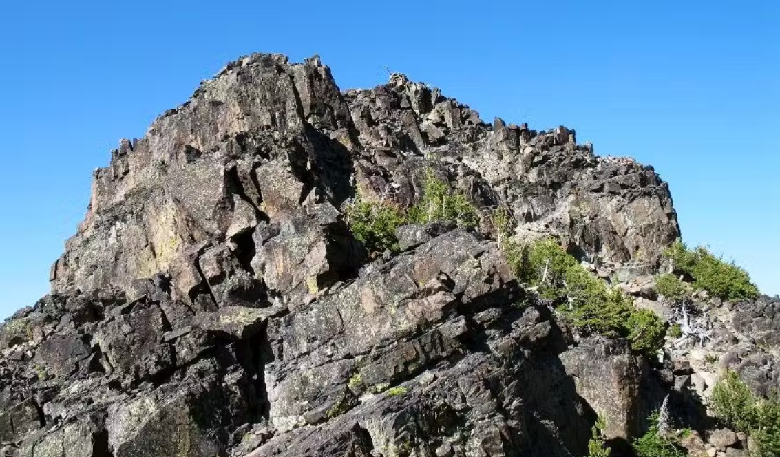
He Devil from the northeast showing major features, the approximate location of the Sheep Lake Trail(123)and a recommended departure area. It is also possible for some who have excellent strength and steep hiking abilities to leave the trail and climb more straight up.
Closeup of the lower NW Ridge to top of He Devil. The easiest access is up the shallow couloir to the deep notch/saddle on the right. Once on the ridge one will notice a short piece of a trial. Trail does not last due to hiking over rock.
The last bit of He Devil involves a scramble/bouldering to get to where the cairn is with a register in a white tube located at the base of the cairn. Once up at the top there are two elevate spots to view the surrounding area. Takes some scrambling/bouldering to get to and from the points.
On the NW Ridge of He Devil. Lakes below are (L to R) Triangle, Quad, He Devil (with island) and Echo. Devils Canyon in the background.
Some of the hiking info by Bob Bolton and photos via Fred Spicker, August 2008


.jpg)
_at_Old_Mission,_Idaho_ca_1885_02.jpg)