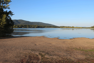
Blanchard Lake
This lake is just south of Blanchard, Idaho off of HWY 41 and is a private lake with public access. When you drive down High Bridge Road to the lake you will see a sign near a farmhouse indicating you must check in before you access the lake. A farming couple owns this lake and is allowing the public to access it via permission first. This farm has a historic museum and a history book of the area that they created is available. The lake is half full of aquatic plants and is known for it's good fishing. Also a good lake to kayak on and view the waterfowl. Locals swim in this lake also. The launch is a large gravel area with lots of parking. There is no restroom or running water. Directions: To access this lake travel east on HWY 41 and when entering the city of Blanchard turn west onto Rusho Ln. While traveling on Rusho Ln a short distance turn south onto High Bridge Road. Follow this road straight to the farmhouse where you sign up to access the lake. The launch access road is on the north side and near the farm house. Maps: Visit google.com/maps type in Antelope Lake, Bonner County, ID. or GPS coordinates 48.007395, -116.978411
 ACCESSIBILITY: PARKING... Dirt/mud parking area; PATHS/TRAILS... None; RESTROOMS/FACILITIES/SHADE… None. Shade via trees; DOCKS/LAUNCHES/PLATFORMS… No dock/platform. Wid dirt/gravel launch area at about 3-4% grade; DIRECT WATER ACCESS… No access for wheeled mobility devices. Access can be via wide launch area but mud will be a problem; TRANSFER SYSTEMS... None; SENSORY... No sensory tactile markers for those with visual and other impairments; CAMPING... None; O.T.H.E.R… Oddities/Barriers: Mud and some marine vegetation along shoreline; Terrain: Level to 4% grades; H2O/Water: Water muddy. Water temperature in the summer can be around 60 to 70 degree. No drinking water available; Environmental Conditions: Varies; Resources: Food, drinks, and gas in town of Blanchard, ID.
This lake is just south of Blanchard, Idaho off of HWY 41 and is a private lake with public access. When you drive down High Bridge Road to the lake you will see a sign near a farmhouse indicating you must check in before you access the lake. A farming couple owns this lake and is allowing the public to access it via permission first. This farm has a historic museum and a history book of the area that they created is available. The lake is half full of aquatic plants and is known for it's good fishing. Also a good lake to kayak on and view the waterfowl. Locals swim in this lake also. The launch is a large gravel area with lots of parking. There is no restroom or running water. Directions: To access this lake travel east on HWY 41 and when entering the city of Blanchard turn west onto Rusho Ln. While traveling on Rusho Ln a short distance turn south onto High Bridge Road. Follow this road straight to the farmhouse where you sign up to access the lake. The launch access road is on the north side and near the farm house. Maps: Visit google.com/maps type in Antelope Lake, Bonner County, ID. or GPS coordinates 48.007395, -116.978411
 ACCESSIBILITY: PARKING... Dirt/mud parking area; PATHS/TRAILS... None; RESTROOMS/FACILITIES/SHADE… None. Shade via trees; DOCKS/LAUNCHES/PLATFORMS… No dock/platform. Wid dirt/gravel launch area at about 3-4% grade; DIRECT WATER ACCESS… No access for wheeled mobility devices. Access can be via wide launch area but mud will be a problem; TRANSFER SYSTEMS... None; SENSORY... No sensory tactile markers for those with visual and other impairments; CAMPING... None; O.T.H.E.R… Oddities/Barriers: Mud and some marine vegetation along shoreline; Terrain: Level to 4% grades; H2O/Water: Water muddy. Water temperature in the summer can be around 60 to 70 degree. No drinking water available; Environmental Conditions: Varies; Resources: Food, drinks, and gas in town of Blanchard, ID.

No comments:
Post a Comment