
Blue Lake (100 acres)
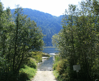
This lake is a private lake with public access in a beautiful forested area. As long as the public respects this lake and takes care of it, it will remain open to the public. This is a "day use area only," and "no wake" lake, so of course jet skis, ski boats, etc. are not allowed. The boat launch is gravel and mud. During low water times of the year the launch is very muddy and not suitable to launch any boats from a trailer (your vehicle and trailer will most likely get stuck). Regardless of the water level the boat launch is only a couple feet deep with a channel extending into the lake through dense aquatic plant life. The lake is almost totally surrounded by aquatic plant life such as lily and dollar pads, and a lot of cattails. There is however broken rock areas along the south shore with some snags. A stream enter the lake creates a beautiful small delta with some sandy areas. Deep creek exits the lake but is hard to see and not accessible due to again extensive aquatic plant life covering and snags. Fishing: Black Crappie, Largemouth Bass, Pumpkinseed Sunfish, Yellow Perch. Lake Dimensions & Coordinates: 100 acres; Maximum depth estimated at 15 ft; elevation 2238 ft; Coordinates T57N R4W Sec 21AH, 22DE. Longitude 116d 49m 20s -to- 116d 49m 57s west. Latitude 48d 16m 29s -to- 48d 16m 48s N. Directions: On HWY 2 coming from either Sandpoint, ID. or Priest River, ID take East Side Rd. (which starts out paved then turns to gravel) to Blue Lake Rd. (this road is just east of the city of Priest River almost next to, and east of, Priest River. Going east on Blue Lake road you will pass a large field and as soon as you enter a small forest area the launch site will be on the south side of the road on a gravel road. In mid October, 2009, there was a private land owner sign indicating this launch site will remain open as long as users take care of the site. Maps: Visit google.com/maps type in Antelope Lake, Bonner County, ID. or GPS coordinates 48.280384, -116.828579
 ACCESSIBILITY: PARKING... Limited dirt parking area along dirt short road at launch site; PATHS/TRAILS... None; RESTROOMS/FACILITIES/SHADE… None. Shade via trees; DOCKS/LAUNCHES/PLATFORMS… No dock/platform. Single lane dirt/mud launch at about 4% grade; DIRECT WATER ACCESS… No access for wheeled mobility devices. Absolutely no access to water other than via launch; TRANSFER SYSTEMS... None; SENSORY... No sensory tactile markers for those with visual and other impairments; CAMPING... No; O.T.H.E.R… Oddities/Barriers: Mud, marine vegetation along shoreline; Terrain: Level to 4% grades; H2O/Water: Water muddy. Water temperature in the summer can be around 60 to 70 degree. No drinking water available; Environmental Conditions: Varies; Resources: Food, drinks, and gas in town of Priest River, ID.
This lake is a private lake with public access in a beautiful forested area. As long as the public respects this lake and takes care of it, it will remain open to the public. This is a "day use area only," and "no wake" lake, so of course jet skis, ski boats, etc. are not allowed. The boat launch is gravel and mud. During low water times of the year the launch is very muddy and not suitable to launch any boats from a trailer (your vehicle and trailer will most likely get stuck). Regardless of the water level the boat launch is only a couple feet deep with a channel extending into the lake through dense aquatic plant life. The lake is almost totally surrounded by aquatic plant life such as lily and dollar pads, and a lot of cattails. There is however broken rock areas along the south shore with some snags. A stream enter the lake creates a beautiful small delta with some sandy areas. Deep creek exits the lake but is hard to see and not accessible due to again extensive aquatic plant life covering and snags. Fishing: Black Crappie, Largemouth Bass, Pumpkinseed Sunfish, Yellow Perch. Lake Dimensions & Coordinates: 100 acres; Maximum depth estimated at 15 ft; elevation 2238 ft; Coordinates T57N R4W Sec 21AH, 22DE. Longitude 116d 49m 20s -to- 116d 49m 57s west. Latitude 48d 16m 29s -to- 48d 16m 48s N. Directions: On HWY 2 coming from either Sandpoint, ID. or Priest River, ID take East Side Rd. (which starts out paved then turns to gravel) to Blue Lake Rd. (this road is just east of the city of Priest River almost next to, and east of, Priest River. Going east on Blue Lake road you will pass a large field and as soon as you enter a small forest area the launch site will be on the south side of the road on a gravel road. In mid October, 2009, there was a private land owner sign indicating this launch site will remain open as long as users take care of the site. Maps: Visit google.com/maps type in Antelope Lake, Bonner County, ID. or GPS coordinates 48.280384, -116.828579
No comments:
Post a Comment