

FISH LAKE
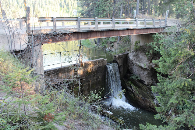
This lake which is a reservoir is also known by locals as Poirier Lake (not to be confused with the small Poirier Reservoir on this page) is a few miles southwest of the city of Blanchard off of Blanchard Rd. or Poirier Ranch Rd. It is a beautiful reservoir set in a wooded area with few houses, known for its fishing and area near Blanchard that one can swim. A small dam under the Blanchard Road bridge created this reservoir keeping its water level up evening in the hot summer months. Fishing: Unknown. Facilities: Primitive dirt and sand launch, no restroom or running water. Open area to camp. There are no signs the last time I checked indicating no camp. Fishing: No info at this time. Directions: See the two access points to this lake with directions below. Maps: See interactive Google at the end of this page and visit google.com/maps type in GPS coordinates 48.002449, -117.001529
 1. Bridge Access
This bridge with small dam under it is at the very northeast end of the lake. Access is on the east side of the bridge through a narrow gate. Directions: From either Blanchard Rd. or Rusho Rd. from HWY 41 in the town of Blanchard take Rusho Rd (also known as High Bridge Rd.) to Poirier Ranch Rd. Follow this road north and then west to the Bridge at this lake. Access is right next to Blanchard Road Bridge (east side of bridge) via a narrow gate, allowing only walk in traffic. One could portage in by carrying their kayak or other over their head and over the fence and follow any of the dirt trails to the water. Maps: See interactive google map below or visit google.com/maps type GPS coordinates 48.004705, -117.001923
 ACCESSIBILITY: PARKING... Gravel, dirt/mud parking along road; PATHS/TRAILS... None; RESTROOMS/FACILITIES/SHADE… None. Shade via trees; DOCKS/LAUNCHES/PLATFORMS… No docks/platforms. No developed launch. Launch from bank after lifting your light weight watercraft over the fence by the gate; DIRECT WATER ACCESS… No access for wheeled mobility devices; TRANSFER SYSTEMS... None; SENSORY... No sensory tactile markers for those with visual and other impairments; CAMPING... Primitive camping at another area of the lake, see #2 below; O.T.H.E.R… Oddities/Barriers: Mud; Terrain: Varies; H2O/Water: Water turning to murky toward mid to late summer. Water temperature in the summer can be around 60 to 70 degree. No drinking water available; Environmental Conditions: Varies; Resources: Food, drinks, and gas in town of Blanchard, ID.
 2. East Access
This access point is not suitable for trailer launching. There are no developed launches on this lake. Directions: From either Blanchard Rd. or Rusho Rd. from HWY 41 in the town of Blanchard take Rusho Rd (also known as High Bridge Rd.) to Poirier Ranch Rd. Follow this road north and before you could make a major right turn on this road you will meet Poirier Ranch Rd. Take this road straight up the hill and at the first major gravel intersection take a right, then go straight and before you could take a major left turn on this road to the right you will see a well traveled dirt road. Follow this road to the reservoir. After you go a couple miles the dirt road will split right or left, stay to the left. Maps: See interactive google map below or visit google.com/maps type GPS coordinates 48.002626, -117.000453
 ACCESSIBILITY: PARKING... Gravel, dirt/mud parking at/near lake shoreline; PATHS/TRAILS... No developed paths. Some wide areas there at the lake shoreline are fairly smooth and level, and there are some single track dirt trails; RESTROOMS/FACILITIES/SHADE… None. Shade via trees; DOCKS/LAUNCHES/PLATFORMS… No docks/platforms. No developed launch. Launch from bank. The bank at this location is not steep and at lower lake levels a small sand beach appears, most of the shoreline is mud with marine vegetation; DIRECT WATER ACCESS… No developed access for wheeled mobility devices; TRANSFER SYSTEMS... None; SENSORY... No sensory tactile markers for those with visual and other impairments; CAMPING... Primitive camping round this access point; O.T.H.E.R… Oddities/Barriers: Mud; Terrain: Varies. Some areas are somewhat level with ground that is fairly hard that wheeled mobility devices could navigate; H2O/Water: Water turning to murky toward mid to late summer. Water temperature in the summer can be around 60 to 70 degree. No drinking water available; Environmental Conditions: Varies; Resources: Food, drinks, and gas in town of Blanchard, ID.
This lake which is a reservoir is also known by locals as Poirier Lake (not to be confused with the small Poirier Reservoir on this page) is a few miles southwest of the city of Blanchard off of Blanchard Rd. or Poirier Ranch Rd. It is a beautiful reservoir set in a wooded area with few houses, known for its fishing and area near Blanchard that one can swim. A small dam under the Blanchard Road bridge created this reservoir keeping its water level up evening in the hot summer months. Fishing: Unknown. Facilities: Primitive dirt and sand launch, no restroom or running water. Open area to camp. There are no signs the last time I checked indicating no camp. Fishing: No info at this time. Directions: See the two access points to this lake with directions below. Maps: See interactive Google at the end of this page and visit google.com/maps type in GPS coordinates 48.002449, -117.001529

This bridge with small dam under it is at the very northeast end of the lake. Access is on the east side of the bridge through a narrow gate. Directions: From either Blanchard Rd. or Rusho Rd. from HWY 41 in the town of Blanchard take Rusho Rd (also known as High Bridge Rd.) to Poirier Ranch Rd. Follow this road north and then west to the Bridge at this lake. Access is right next to Blanchard Road Bridge (east side of bridge) via a narrow gate, allowing only walk in traffic. One could portage in by carrying their kayak or other over their head and over the fence and follow any of the dirt trails to the water. Maps: See interactive google map below or visit google.com/maps type GPS coordinates 48.004705, -117.001923

This access point is not suitable for trailer launching. There are no developed launches on this lake. Directions: From either Blanchard Rd. or Rusho Rd. from HWY 41 in the town of Blanchard take Rusho Rd (also known as High Bridge Rd.) to Poirier Ranch Rd. Follow this road north and before you could make a major right turn on this road you will meet Poirier Ranch Rd. Take this road straight up the hill and at the first major gravel intersection take a right, then go straight and before you could take a major left turn on this road to the right you will see a well traveled dirt road. Follow this road to the reservoir. After you go a couple miles the dirt road will split right or left, stay to the left. Maps: See interactive google map below or visit google.com/maps type GPS coordinates 48.002626, -117.000453
No comments:
Post a Comment